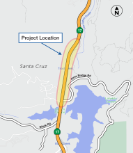
The Santa Clara Valley Transportation Authority (VTA), in cooperation with Midpeninsula Regional Open Space District (Midpen) and the California Department of Transportation (Caltrans), proposes to construct new wildlife undercrossing and trail overcrossing structures near Lexington Reservoir on State Route 17 (SR 17) south of the Town of Los Gatos.
Objectives
The new wildlife undercrossing and trail overcrossing structures would link over 30,000 acres of habitat and protected public lands on both sides of SR 17. The new undercrossing would provide wildlife the ability to find food and mates in support of healthy wildlife populations, and enhance safety for motorists and wildlife by reducing the potential for collisions. The new trail overcrossing would connect over 50 miles of regional trails, including the Bay Area Ridge Trail, Juan Bautista de Anza National Historic Trail, and Los Gatos Creek Trail.
Project Features
The proposed improvements include, but are not limited to, the following:
• A new wildlife undercrossing structure with associated sound walls, wildlife directional fencing, and wildlife escape ramps.
• A new trail overcrossing.
• New or improved existing trail segments connecting public lands.
• New retaining walls as needed.
