Transportation Demand Management - Home Page

Traditional efforts to meet increasing travel demand are typically based on a supply-oriented approach largely supported by the lack of physical and fiscal limitations on where, when, and how...
Traditional efforts to meet increasing travel demand are typically based on a supply-oriented approach largely supported by the lack of physical and fiscal limitations on where, when, and how...

The Diridon Station will be between Montgomery and Cahill Streets, on the south side of Santa Clara Street.
Ticketing, fare gates, and bicycle facilities will be at street-level while the station’s...
Originally invented as a tool to separate housing from hazardous industrial activities, zoning serves as the primary tool that local jurisdictions use to regulate land uses. However, traditional...
The Community Design and Transportation Manual (CDT) is designed to inspire new thinking about the form and function of growth, broaden and strengthen the range of transportation choices, and make the...


Bring together various community development stakeholders to identify shared project objectives and transit integration opportunities and challenges at the earliest stage in the process to...

Austin, TX, USA - Smart Growth Matrix
To streamline the review process, give a clear sense of development expectations, and provide a financial incentive for Smart Growth, the City of Austin (Texas...
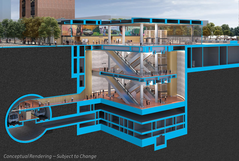
Downtown San José Station will be on Santa Clara Street between Market and 1st Streets. Ticketing and fare gates will be at street-level while the station’s concourse and platforms will be...
Communities designed to enable people to accomplish daily activities in equal comfort through multiple transit modes lead to healthy, vibrant public life. Concentrating services, activities, and...

The design of new development is often driven by the physical planning requirements and outlined in zoning codes. Setbacks, height and bulk limits, and building density are factors that directly...


Plan for neighborhood integration to ensure that new development and the proposed urban pattern provide a natural transition in size, scale, and character to adjacent neighborhoods.

Integrate Tra...

Fort Collins, CO, USA - Multimodal Level of Service Standards
The City of Fort Collins was one of the first cities to adopt Multimodal Level of Service (MMLOS) standards to evaluate how projects...

The design of parking facilities plays a significant role in a transportation system as parking is always the very start and end of any passenger vehicle trip. Parking design and layout has a...


Establish parking maximums to set a cap of parking needed for specific zones and reduce the potential for an overabundance of parking to detract from an area.

Visual cues, landmarks, and useful signage orient pedestrians with their surroundings and destinations and provide safe and easy navigation. Clear sight lines to and from station stops increase...

Mountain View, California, USA – Innovative Development Standards
The City of Mountain View approved the East Whisman Precise Plan in 2019 with special standards requiring that new development...


Provide secure and convenient cycling and micro-mobility amenities including, but not limited to, bike racks, bike lockers, and bike and scooter share to encourage multi-modal transportation.


Every street is a transportation link for every mode; differences are based on the balance of how each mode is prioritized. Street design should complement surrounding land uses and support walking...


Provision high environmental quality parking facilities that improve water quality by filtering and cooling though stormwater best management practices, including vegetated swales and rain gardens...
-SPUR-SergioRuiz")